Who can request information?We currently provide information for the following customer types:
- Commercial – CHARGEABLE e.g. ecology consultants, developers & land agents
- Neighbourhood Plans – For Parish Councils and Neighbourhood Plan Groups
- Naturalists – e.g. County Recorders' Network, Local Conservation/Recording Groups
- Charitable Organisation – e.g. Local Wildlife Trust. For non-profit, non-commercial uses only
- Academic – e.g. schools, university students and research institutions
- Public – Members of the public interested in wildlife in their area
- Internal – For Internal Leicestershire County Council enquires only
To request information from us you will need to use our simple online Data Request form. This provides us with details of who you are, what information you require and the geographic area you are interested in.
How much will it cost?We offer a number of standard search packages, which include species and sites data. Prices apply only to Commercial data requests. Other types of data request are usually free of charge. Please see our Charging and Data Supply Policy for more information on this
https://www.leicestershire.gov.uk/sites/default/files/field/pdf/2021/6/9/LRERC-charging-and-data-supply-policy.pdfNot all packages may be available for all customer types.
- Package A1 – from £198 + VAT: 1km - Designated sites; Protected/Priority species – SSSI/SAC/SPA etc; Local sites/LWS/RIGS; PS/UK+LBAP/S41/INNS
- Package A2 – from £397 + VAT: 2km - Designated sites; Protected/Priority species – SSSI/SAC/SPA etc; Local sites/LWS/RIGS; PS/UK+LBAP/S41/INNS
- Package B1 – from £129 + VAT: 1km - Designated Sites; Protected species – SSSI/SAC/SPA/etc; Local sites/LWS/RIGS; PS
- Package B2 – from £258 + VAT: 2km - Designated Sites; Protected species – SSSI/SAC/SPA/etc; Local sites/LWS/RIGS; PS
- Package C1 – from £100 + VAT: 1km - All Designated sites only – SSSI/SAC/SPA/etc; Local sites/LWS/RIGS
- Package C2 – from £198 + VAT: 2km - All Designated sites only – SSSI/SAC/SPA/etc; Local sites/LWS/RIGS
- Package D1 – from £100 + VAT: 1km - Protected and Priority species – PS/UK+LBAP/S41/INNS
- Package D2 – from £198 + VAT: 2km - Protected and Priority species – PS/UK+LBAP/S41/INNS
- Package E1 – from £32 + VAT: 1km - Protected species – PS
- Package E2 – from £59 + VAT: 2km - Protected species – PS
- Package NP – No Charge: Neighbourhood Plans – Protected and Priority Species, Designated Sites, Alert Layers for your parish
- Package P – No Charge: Member of the Public – A summary list of species found within your area
In addition, we charge the following for each enquiry:
- Administration Fee – £41 + VAT
All charges are subject to VAT.
You will receive an instant quote for the search. As soon as you accept the quote and submit your request, we will process the data.
Our invoicing is managed outside of the MyLERC website and will be sent separately to the results of your datasearch. All payments for datasearches from Leicestershire and Rutland Environmental Records Centre should be made to Leicestershire County Council. Payment details will be provided on the invoice or are available in advance direct from LRERC.
How do I request data that doesn't fall into one of the standard packages?If your data request does not fall within our standard packages, we will carry out a custom search at an additional cost.
Additional cost for a custom search:
●
Custom Search Administration Fee – £65 + VATOther additional costs (where applicable)● Hourly rate (for document searches) – prices available from LRERC upon request
● Printing - prices available from LRERC on request
● Postage – Standard 2nd class
When will I get the results of my search?We aim to provide:
● all standard packages within
one working day● custom searches within
five working daysThis is subject to request type, search area size and working hours.
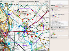
What will I receive?For most types of data requests, results are made available through the eMapper system, with lots of useful features:
● Interactive mapping of species and sites on Ordnance Survey Maps, Aerial Photos and other background layers
● Customisable display of species records
● Filter records by year, distance, resolution, species list and more
● Download records in PDF, Excel or Shapefile formats
Where a search returns an extremely large number of records, we may supply Excel and GIS files instead of eMapper access.
What if my search buffer crosses outside of Leicestershire and Rutland?Please submit your search as normal, you will not be charged for the area outside of our boundary and this will be reflected in your quote. You are also advised to contact the neighbouring LERC for the remaining area. Details of LERCs can be found on the
ALERC website.
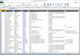
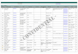
View examples of our outputsUsing eMapper you have the ability to customise your own reports in PDF, Excel or Shapefile format, using all the data or a filtered subset.
eMapper Sample
Adobe PDF Sample
Microsoft Excel Sample