DBRC – Data Request
Need Help? Email us at dataenquiries@derbyshirewt.co.uk
LERC Logo
My LERC is an online system and requires a My LERC log in. You can create a 'My LERC account', if you have not previously done so, on the next page.

Who can request information?

When requesting an Ecological Data Search you will be asked to choose from one of the following Data Search Types:

Commercial - for consultants, local authorities, landowners and developers seeking information for development or commercial management of land, e.g. for planning applications, agri-environment schemes etc. There is normally a charge for these searches.
Neighbourhood Plan - for Parish Councils for Parish Planning purposes only. There is normally a charge for these searches.
Non-commercial - for members of the public, volunteer wildlife recorders, landowners looking to manage their land for nature conservation, students and other researchers. There is usually no charge for these searches.

To request information from us you will need to complete a simple online form. To request an Ecological Data Search click on 'Begin Data Request' at the bottom of this page, or for further information on DBRC's Ecological Data Search service, click on the drop down menus below.

How much will it cost?

We offer a number of standard search packages, which include species, habitat and sites data. Not all packages may be available for all enquiry types. Requesting data outside standard packages will require a Custom Search. These will be quoted separately and may be provided in a different format and within a different timescale than the Standard Packages. Please email dataenquiries@derbyshirewt.co.uk


What will I receive?

You will receive an instant quote for the search, so as soon as you accept the quote and submit your request, we can provide you with the data.

We aim to provide all standard package data within working 10 days, although in most cases you will receive the information on the same day that you submitted your enquiry. We do not provide a 'fast-track' service due to the speed of our normal turnaround.
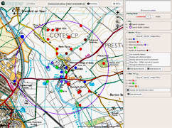
For standard data requests, results are made available through our unique eMapper system, with lots of useful features:

● Interactive mapping of species and sites on Ordnance Survey Maps, Aerial Photos and other background layers
● Customisable display of species records
● Filter records by year, distance, resolution, species list and more
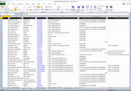
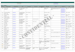
● Download records in PDF, Excel or Shapefile formats

Where a search returns an extremely large number of records, we may supply Excel and GIS files instead of eMapper access.

View examples of our outputs. Using eMapper you have the ability to customise your own reports in PDF, Excel or Shapefile format, using all the data or a filtered subset.

eMapper Sample
Sample of data displayed on our eMapper system
Adobe PDF Sample
Sample of our Adobe PDF output
Microsoft Excel Sample
Sample of our Microsoft Excel output


This Data Request process is delivered in partnership with Cofnod. If you need help with the data request process please email help@lerc.online.